News
Home | News | Mapping Flood Extents Using Sentinel-1 Data
Mapping Flood Extents Using Sentinel-1 Data
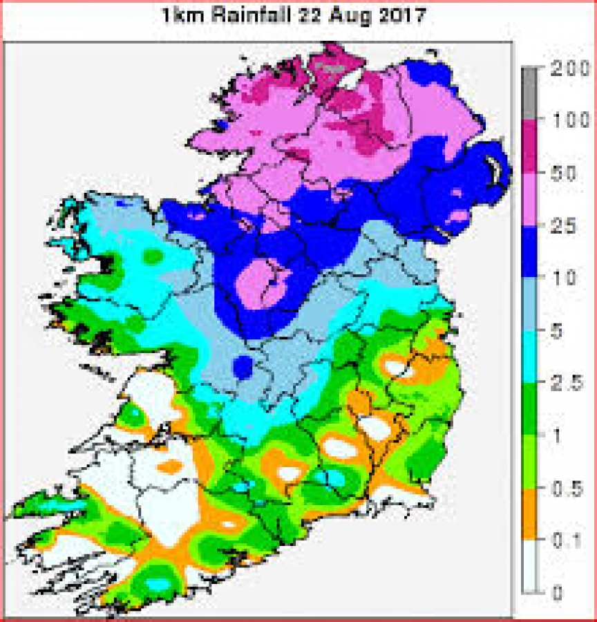
Flooding across Ireland causes substantial damage to property, infrastructure and the environment each year, and has significant economic and social impacts upon all those communities affected. Heavy rain in late August this year saw flash flooding across parts of counties Donegal, Derry and Tyrone causing economic and social difficulties for both rural and urban dwellers. Flooding caused damage to infrastructure and agriculture around Derry city, and even forced the closure of the City of Derry Airport. Torrential rain on the 22nd of August led to the rivers Faughan and the Finn bursting their banks. The chart below (figure 1) from Met Eireann shows how much rainfall fell over a relatively short space of time. Figure 2 shows how this torrential rain was especially concentrated around areas of Donegal, Derry and Tyrone.
Figure 1 Source - met.ie
Figure 2 Source - visitinishowen.com
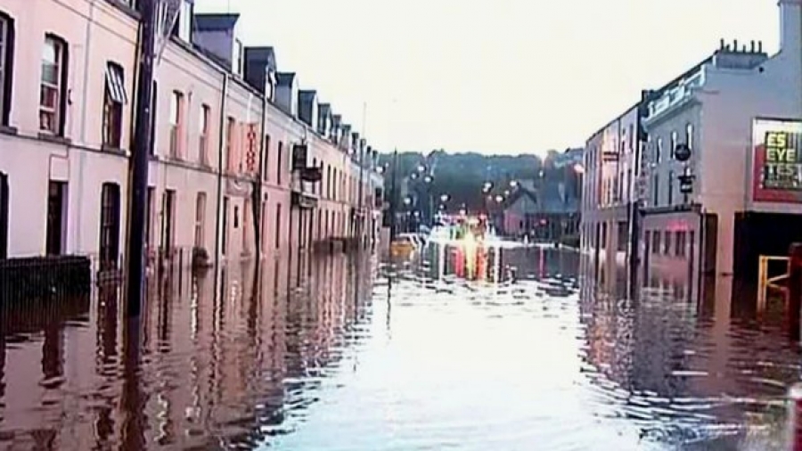
The images below show some of the damage caused by the flooding
Figure 3 Source - RTE.ie
Figure 4 Source - bbc.co.uk
Using Satellite Imagery to Map Flooded Areas
Mapping flooded areas can be a very useful and important undertaking after flooding has occurred. Not only can it help to identify flooded areas, which can aid emergency response, it can also assist with long-term planning and defence against flooding in the future. One method for mapping such floods is to use Remote Sensing and GIS techniques. Satellite data can prove very useful for carrying out such an endeavour. The EU’s Copernicus programme includes various satellite constellations for monitoring different environmental features across the globe. The Sentinel-1 and Sentinel-2 constellations are especially useful for monitoring and assessing environmental variables at medium resolutions. Both Sentinel-1 and Sentinel-2 constellations are comprised of two satellites. The Sentinel-1 satellites (1A and 1B) are synthetic aperture radar (SAR) platforms, while the Sentinel-2 satellites (2A and 2B) are multispectral optical imaging platforms. Furthermore, all the data is open source and is thus freely available.
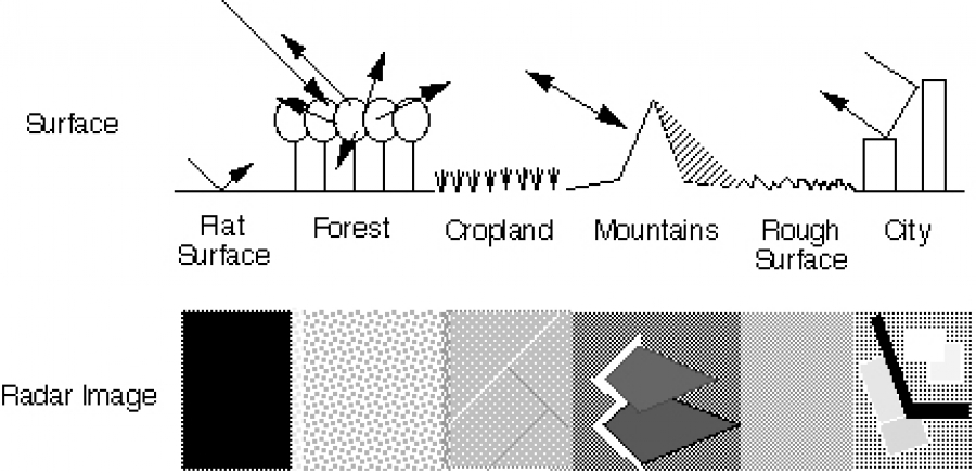
While multispectral optical data may seem like the best option to use given its greater fidelity to land cover features in relation to our visual perceptions, it is not always the most useful option. As optical imagery can’t ‘see’ through clouds, it is often of little use when monitoring flooding given the inevitable preponderance of cloud cover over the areas affected. By contrast, radar sensors transmit and receive microwave signals which penetrate cloud and which can also capture data during both the day and the night. Furthermore, radar data is particularly suitable for monitoring flooding due to the type of data that is captured by a radar signal. Where optical satellite data signals provide information about the reflectance of features on the ground, radar signals respond primarily to the textural properties of these features, and to their dielectric constant. When a radar pulse encounters an object, it is scattered in various directions depending on the texture and angles of the object. The radar sensor measures the backscatter of the signal. In general, the higher or brighter the backscatter on an image, the rougher the surface being measured. Flat surfaces reflect very little of the signal back towards the sensor and therefore tend to appear dark on an image. The top part of figure 5 shows a diagram of a radar signal’s interaction with different types of surfaces, and how this signal is correspondingly scattered. The bottom part of figure 5 shows what we would expect to see on the resulting image for each corresponding interaction.
Figure 5: Source: Airsar
The most important thing to note in relation to monitoring flooding is that water, especially in inland waterways, tends to be flat and smooth. Therefore, we would expect areas of inland water (with the potential exception perhaps of very sizeable lakes) to appear very dark in radar images.
An additional issue when it comes to flood monitoring is the fact that excess water in flooded areas can drain away quite rapidly with the result that there may only be a small window of time to capture the flooded areas on satellite imagery. Sentinel-1 has a current revisit time of approximately three days over Ireland which dramatically improves the chances of being able to map the affected areas concerned.
Processing the Sentinel-1 SAR Imagery
Identifying flooding using SAR data generally involves some form of change detection analysis. Change detection analysis looks at differences between images over time to identify any significant changes in the features under observation. In terms of flooding, we would expect that the radar signal backscatter returns for pre-flooded areas would be higher than for the same areas once flooded. A pre-flooded area such as a field should have far higher backscatter returns due to its greater surface roughness. Once submerged, the backscatter returns should be minimal, given the smooth and flat characteristics of water bodies.As shown previously, the floods in the north-west of Ireland were primarily the result of some torrential rains which fell on the evening of 22nd of August 2017. Much of the flooding had subsided within a couple of days. To carry out change detection analysis, at least two images are required: one before the flooding, and one during the flooding while areas are still under water. Therefore, it was crucial to obtain an image within a day or two of the torrential rains, before the flooding had subsided. Fortunately, given the high revisit time of Sentinel-1, a pre-flooding image from the 11th August 2017 and a during-flooding image from the 23rd of August 2017 were available. Processing these images to carry out change detection analysis involved the following key stages:
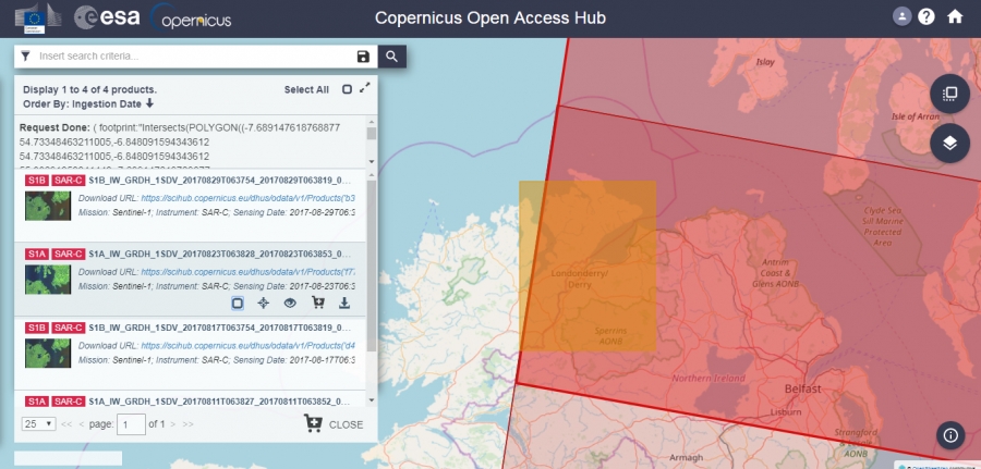
1)Searching for and downloading the relevant (GRD) Sentinel-1 imagery from the Copernicus Open Access Hub.
Figure 6: Copernicus Open Access Hub
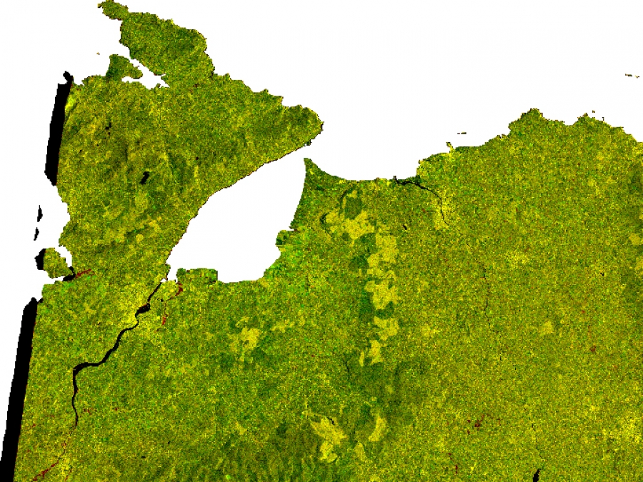
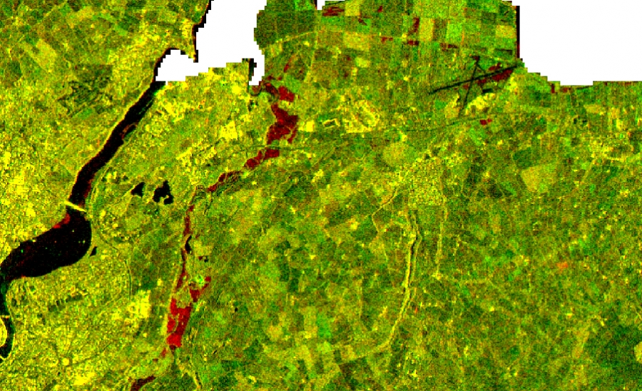
2) Creating and executing processing chains in the open source ESA Snap Toolbox to radiometrically calibrate, co-register, speckle filter, terrain correct and subset the GRD SAR images. Figure 7 shows two corrected and overlaid Sentinel-1 images from 11th August 2017 and 23rd August 2017 of parts of Donegal, Derry and Tyrone. The earlier image is projected through the red channel and the later image through the green channel, creating a composite image. Given that the scattered signal returns for flooded areas are much lower in the later image than the earlier image, flooded areas appear red in the composite image. This can be seen much more clearly in figure 8.
Figure 7: Calibrated, co-registered, speckle-filtered, terrain corrected Sentinel-1 GRD images
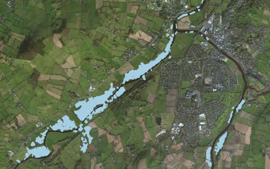
3) Creating a difference image and thresholding this image to try to isolate the pixels representing flooding in the imagery. Figure 8 shows a close up of some of the flooded areas to the east of Derry City. As described previously, the flooded areas show up in red. Figure 9 shows the result of an applied threshold to a difference image overlaid on the composite image. The applied threshold has primarily isolated flooded pixels, which are coloured in blue.
Figure 8: Composite image showing flooded areas in red
Figure 9: Flooded pixels isolated by applying a threshold to a difference image
4) Further post-processing of the imagery to try to clean up the data and remove misclassified pixels. Figure 10 shows a thresholded image similar to that in figure 9, but with many misclassified pixels removed.
Figure 10: Thresholded image with many misclassified pixels removed
5) Creating a vector layer of the flooding. Figure 11 shows a vector layer of the flooding around Strabane overlaid on a Bing aerial map.
Figure 11: Vector layer of flooding around Strabane
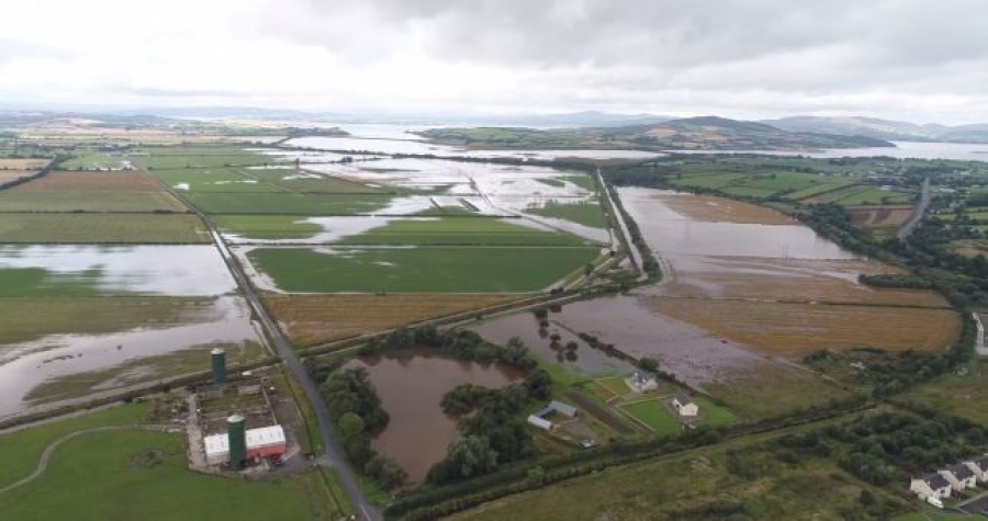
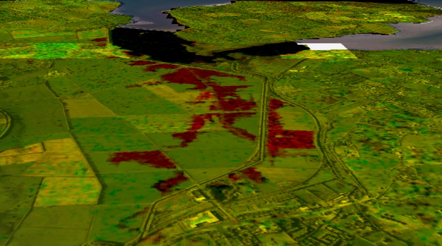
All the work in these examples was carried out using two open source pieces of software: ESA Snap Toolbox and QGIS. As discussed above, the flooded areas show up particularly strongly in Sentinel-1 SAR data when we combine images from different dates into composite images. In the examples here, the composite image can be checked against some photographs taken of affected areas at the time of the flooding. Additionally, the Qgis2threejs plugin can be used to create 3D views of the data so it can be rotated to better compare it to the photographic evidence available. The example below (figure 12) shows an area of flooding just west of Burnfoot in Co. Donegal. The red flooded areas in the Sentinel-1 composite image (figure 13) match up very well with the flooded areas visible on the photograph.
Figure 12: Source: Belfast Telegraph
Figure 13: Blended, composite Sentinel-1 image of flooding near Burnfoot, Co. Donegal (blended with a Bing Aerial Map)
Sharing and Exploring the Data with Azimap
We can take this process one step further by loading the data into Azimap and using some of the advanced features available. Azimap provides a platform to share spatial data. However, additional features can also be utilised within Azimap to improve this data for end users. In this case, it is possible to upload the flooding vector data and to sync photographs to certain flood polygons. Now the end user can not only see where flooding occurred, but can also access additional information and sources which may be useful for assessing and building strategies to deal with such events.
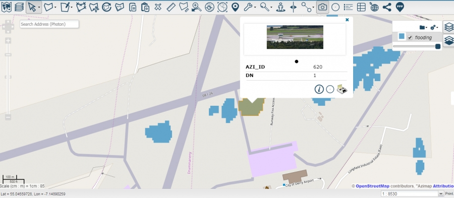
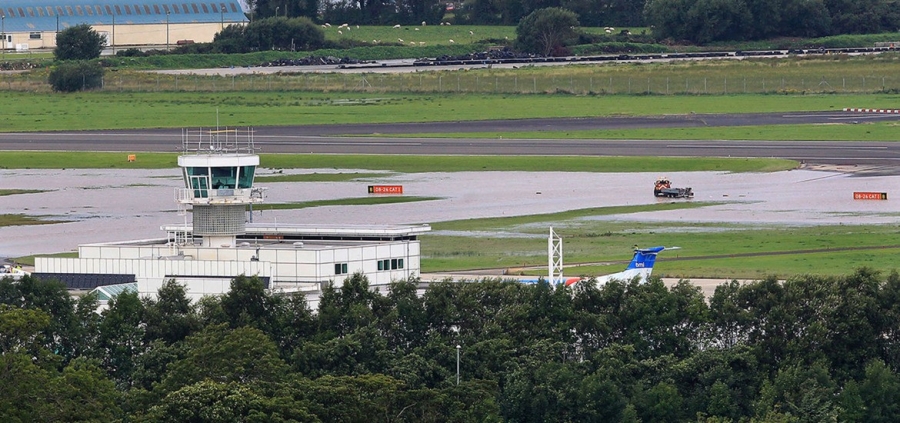
In the example below, I have uploaded a photograph and associated it to the relevant flood polygons in the vector dataset in Azimap. When the user clicks on one of these polygons, the associated photograph appears on the feature pop-up above the attribute details. The example (figure 14) shows a flood polygon on the grounds of the City of Derry Airport. An associated photograph can be seen in the attribute popup, revealing the extent of some of the flooding around the runway. This thumbnail can be clicked to enlarge the photograph (figure 15).
Figure 14: Flood Polygon Azimap
Figure 15 Source: Irish News


